Geology of Mars
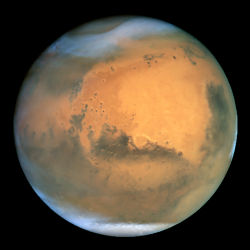
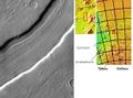
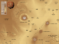
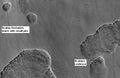
Mars as seen by the Hubble Space Telescope
|
||||||||||
|
Designations
|
||||||||||
|---|---|---|---|---|---|---|---|---|---|---|
| Adjective | Martian | |||||||||
| Epoch J2000 | ||||||||||
| Aphelion | 249,209,300 km 1.665861 AU |
|||||||||
| Perihelion | 206,669,000 km 1.381497 AU |
|||||||||
| Semi-major axis | 227,939,100 km 1.523679 AU |
|||||||||
| Eccentricity | 0.093315 | |||||||||
| Orbital period | 686.971 day 1.8808 Julian years |
|||||||||
| Synodic period | 779.96 day 2.135 Julian years |
|||||||||
| Average orbital speed | 24.077 km/s | |||||||||
| Inclination | 1.850° 5.65° to Sun's Equator |
|||||||||
| Longitude of ascending node | 49.562° | |||||||||
| Argument of perihelion | 286.537° | |||||||||
| Satellites | 2 | |||||||||
|
Physical characteristics
|
||||||||||
| Equatorial radius | 3,396.2 ± 0.1 km[a][2] 0.533 Earths |
|||||||||
| Polar radius | 3,376.2 ± 0.1 km[a][2] 0.531 Earths |
|||||||||
| Flattening | 0.00589 ± 0.00015 | |||||||||
| Surface area | 144,798,500 km² 0.284 Earths |
|||||||||
| Volume | 1.6318 × 10¹¹ km³ 0.151 Earths |
|||||||||
| Mass | 6.4185 × 10²³ kg 0.107 Earths |
|||||||||
| Mean density | 3.934 g/cm³ | |||||||||
| Equatorial surface gravity | 3.69 m/s² 0.376 g |
|||||||||
| Escape velocity | 5.027 km/s | |||||||||
| Sidereal rotation period |
1.025957 day 24.62296 h[3] |
|||||||||
| Equatorial rotation velocity | 868.22 km/h | |||||||||
| Axial tilt | 25.19° | |||||||||
| North pole right ascension | 21 h 10 min 44 s 317.68143° |
|||||||||
| North pole declination | 52.88650° | |||||||||
| Albedo | 0.15[4] | |||||||||
| Surface temp. Kelvin Celsius |
|
|||||||||
| Apparent magnitude | +1.8 to −2.91[4] | |||||||||
| Angular diameter | 3.5" — 25.1"[4] | |||||||||
|
Atmosphere
|
||||||||||
| Surface pressure | 0.7–0.9 kPa | |||||||||
| Composition | 95.72% Carbon dioxide 2.7% Nitrogen |
|||||||||
The geology of Mars refers to the scientific study of the surface, crust, and interior of the planet Mars. It emphasizes the composition, structure, history, and physical processes that shape the planet. It is fully analogous to the field of terrestrial geology. In planetary science, the term “geology” is used in its broadest sense to mean the study of the solid parts of planets. The term incorporates aspects of geophysics, geochemistry, geodesy, and cartography[5]. The neologism “areology,” from the Greek Ἂρης (Arēs or Mars), as a synonym for Mars' geology sometimes appears in the popular media and works of science fiction (e.g., Kim Stanley Robinson’s Mars trilogy)[6], but the term is rarely used by professional geologists and planetary scientists.
Contents |
Elemental composition
Elements present on Mars include among others oxygen (O), iron (Fe), and silicon (Si), along with significant amounts of magnesium (Mg), aluminum (Al), sulfur (S), calcium (Ca) and titanium (Ti). The planet's distinctive red coloration is largely due to the oxidation of its surface iron. Recently Mars soil was found to contain ice trapped in minerals. It was also found to contain potassium (K), chlorine (Cl) and sodium (Na).[7]
Scientists have learned about the elemental composition of Mars from several sources. A number of space probes have landed on the planet; some were able to move around. The Viking program was the first to land two robots on Mars. The Pathfinder mission included the Sojourner rover which analyzed rocks, as well as the soil. The Phoenix lander landed very far to the North. Two Mars Exploration Rovers have been crawling on the Martian surface for over 5 years so far. These probes carried instruments that analyzed the surface. We also have many actual samples of Mars in the form of meteorites that have made their way to Earth. These meteorites are called SNC's, for Shergottites meteorites, Nakhla meteorite, Chassigny meteorite.[8] Some orbiting space craft have instruments that can actually map the distribution of some chemicals.
Timeline
Crater density timeline
Studies of impact crater densities on the Martian surface allow us to identify three broad epochs in the planet's geological timescale, as older surfaces have many craters and younger ones have few.[9] The epochs were named after places on Mars that belong to those time periods. The precise timing of these periods is not known because there are several competing models describing the rate of meteor fall on Mars, so the dates given here are approximate. From oldest to youngest, the time periods are:
- Noachian epoch (named after Noachis Terra): Formation of the oldest extant surfaces of Mars between 4.6 and 3.5 billion years ago. Noachian age surfaces are scarred by many large impact craters. The Tharsis bulge is thought to have formed during this period, with extensive flooding by liquid water late in the epoch.
- Hesperian epoch (named after Hesperia Planum): 3.5 to 1.8 Ga BP. The Hesperian epoch is marked by the formation of extensive lava plains. Formation of Olympus Mons likely began during this epoch[10].
- Amazonian epoch (named after Amazonis Planitia): 1.8 Ga BP to present. Amazonian regions have few meteorite impact craters but are otherwise quite varied. Lava flows on Mars continued during this period.

The studying of craters is based upon the assumption that crater-forming impactors have hit the planet all throughout history at regular intervals, and there is no way to exactly date an area just based upon the number of impacts, only to guess that areas with more impacts must be older than areas with fewer impacts. For example this logic breaks down if a large number of asteroids had hit at once, or if there were long periods where few asteroids hit.
Mineralogical timeline
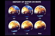
Based on recent observations made by the OMEGA Visible and Infrared Mineralogical Mapping Spectrometer on board the Mars Express orbiter, the principal investigator of the OMEGA spectrometer has proposed an alternative timeline based upon the correlation between the mineralogy and geology of the planet. This proposed timeline divides the history of the planet into 3 epochs; the Phyllocian, Theiikian and Siderikan.[11][12]
- Phyllocian (named after the clay-rich phyllosilicate minerals that characterize the epoch) lasted from the formation of the planet until around 4000 million years ago. In order for the phyllosilicates to form an alkaline water environment would have been present. It is thought that deposits from this era are the best candidates to search for evidence of past life on the planet. The equivalent on Earth is much of the hadean eon.
- Theiikian (named, in Greek, after the sulfate minerals that were formed), lasting until about 3500 million years ago, was a period of volcanic activity. In addition to lava, gasses - and in particular sulfur dioxide - were released, combining with water to create sulfates and an acidic environment. The equivalent on Earth is the eoarchean era and the beginning of the paleoarchean era.
- Siderikan, from 3500 million years ago until the present. With the end of volcanism and the absence of liquid water, the most notable geological process has been the oxidation of the iron-rich rocks by atmospheric peroxides, leading to the red iron oxides that give the planet its familiar color. The equivalent on Earth is most of the archean all of the proterozoic and phanerozoic up to now.

Minerals
Today, scientists are quite confident about what minerals exist on the Red Planet. There is strong evidence that olivine, pyroxene, feldspar, hematite, clay, goethite, jarosite, iron sulfates, and opaline silica exist on Mars.
Mars, like the Earth, has long been thought to be covered with a great deal of the volcanic rock basalt. Appropriately, minerals derived from this rock are found on the surface. Olivine, pyroxene, and feldspar result from the simple mechanical break down of basalt. Many other minerals were formed from the interaction of basalt with water. Clay, also known as phyllosilicate, occurs only after long exposure to water.[8]
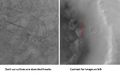
Spectra from the NASA THEMIS probe have shown the possibility of the mineral olivine on Mars by looking for the characteristic infra-red radiation it emits. The discovery is interesting because the mineral, which is associated with volcanic activity, is very susceptible to weathering by water, and so its presence and distribution which can be obtained from satellite could tell us about the history of water on Mars.
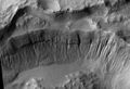
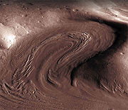
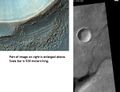
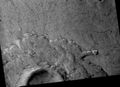
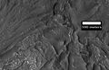
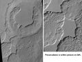
Olivine forms from magma and weathers into clays or iron oxide. The researchers found olivine all over the planet, but the largest exposure was in Nili Fossae, a region dating from >3.5 Ga (the Noachian epoch). Another outcrop is in the Ganges Chasma, an eastern side chasm of the Valles Marineris (pictured).[13]
Opaline silica and iron sulfates form in acid solutions, so parts of Mars may have had lakes of acid. These two minerals have been found in a variety of locations, including near Juventae Chasma, Ius Chasma, Melas Chasma, Candor Chasma, and Ganges Chasma. These sites all contain valleys or channels indicating abundant water.[14][15]
Positive identification of Martian minerals were made with orbiting space craft like the Mars Reconnaissance Orbiter, as well as with two rovers on the surface--Spirit Rover and Opportunity Rover. Examination of a variety of meteorites from Mars has also yielded knowledge of the minerals on Mars.[16] Much detailed information about minerals on the Martian surface was described in 2009 based on a full Mars year of observations from MRO. Aqueous minerals belonging to 9-10 classes were found in thousands of places. Two to five classes of old deposits may have been formed in environments suitable for life. These deposits had enough water and the proper pH for life to develop. Smectite clays were found, and they form in near-neutral waters. Some of the minerals found such as phyllosicates and carbonates are good for preserving organic matter, so they may contain evidence of past life. [17] [18]
Detecting and mapping minerals on Mars are important for the search for life. Life may not be found with the mineral olivine because olivine would not last long around water. On the other hand, sulfate deposits preserve chemical and morphological fossils; iron oxides (like hematite) can even form fossils of microorganisms.[19] The presence of silica deposits (like opaline silica) points toward a hydrothermal environment that could support life. silica is also excellent for preserving evidence of microbes.[20]
Surface chemistry
The surface of Mars is thought to be primarily composed of basalt, based upon the observed lava flows from volcanos, the Martian meteorite collection, and data from landers and orbital observations. The lava flows from Martian volcanos show that lava has a very low viscosity, typical of basalt.[21] Analysis of the soil samples collected by the Viking landers in 1976 indicate iron-rich clays consistent with weathering of basaltic rocks.[21] There is some evidence that some portion of the Martian surface might be more silica-rich than typical basalt, perhaps similar to andesitic rocks on Earth, though these observations may also be explained by silica glass, phyllosilicates, or opal. Much of the surface is deeply covered by dust as fine as talcum powder. The red/orange appearance of Mars' surface is caused by iron(III) oxide (Fe2O3) (rust).[22] Mars has twice as much iron oxide in its outer layer as Earth does, despite their supposed similar origin. It is thought that Earth, being hotter, transported much of the iron downwards in the 1,800 km deep, 3,200 °C, lava seas of the early planet, while Mars, with a lower lava temperature of 2,200 °C was too cool for this to happen.[22] While the possibility of carbonates on Mars has been of great interest to exobiologists and geochemists alike, there was little evidence for significant quantities of carbonate deposits on the surface until recently. In the summer of 2008 the TEGA and WCL experiments on the 2007 Phoenix Mars lander found between 3-5wt% calcite (CaCO3) and an alkaline soil.[23] In 2010 analyses by the Mars Exploration Rover Spirit, identified outcrops rich in magnesium-iron carbonate (16-34 wt%) in the Columbia Hills of Gusev crater, most likely precipitated from carbonate-bearing solutions under hydrothermal conditions at near-neutral pH in association with volcanic activity during the Noachian era.[24]
Magnetic field and internal structure
Although Mars today has no global-scale intrinsic magnetic field, observations have been interpreted as showing that parts of the planet's crust have been magnetized and that polarity reversal of its dipole field occurred when the central dynamo ceased, leaving only residual permanent crustal fields.[25][26] This Paleomagnetism of magnetically susceptible minerals has features very similar to the alternating bands found on the ocean floors of Earth. One theory, published in 1999 and re-examined in October 2005 with the help of the Mars Global Surveyor, is that these bands are evidence of the past operation of plate tectonics on Mars 4 Ga ago, before Mars' planetary dynamo ceased.[27] The magnetization patterns in the crust also provide evidence of past polar wandering, the change in orientation of Mars' rotation axis.[26][28]
Mars' magnetic field varies over its surface, and while it is mostly very small it can in places be locally as high as on Earth. It is possible to date the time when Mars' dynamo turned off. The large impact basins Hellas and Argyre, aged 4 Ga, are unmagnetised, so the dynamo would have to have turned off before then otherwise the molten rock would have remagnetised.[29] An alternative theory advanced by Benoit Langlois is that a lunar-scale object struck the northern hemisphere at a shallow angle and high latitude at about 4.4 Ga.[30] Computer models by Sabine Stanley show that this would have created a convection current powered dynamo in the southern hemisphere.[31]
Gravity
Mars has approximately half the radius of Earth and only one-tenth the mass, which generates a surface gravity of 0.376 g, that is only about 38% of the surface gravity on Earth.
Core
Current models of the planet's interior suggest a core region between 1520 and 1840 km in radius[32][33] (roughly half the total radius), consisting primarily of iron with about 14-16% sulfur[33]. This iron sulfide core is partially or completely fluid[33], with twice the concentration of light elements that exists at Earth's core. The high sulfur content of Mars' core gives it a very low viscosity which, along with evidence from tungsten isotopes[34], implies that Mars' core formed very early on in the planet's history.
Crust and mantle
The core is surrounded by a silicate mantle that formed many of the tectonic and volcanic features on the planet. The average thickness of the planet's crust is about 50 km, and it is no thicker than 125 km,[35] which is much thicker than Earth's crust which varies between 5 km and 70 km. A recent radar map of the south polar ice cap showed that it does not deform the crust despite being about 3 km thick.[36]
Tectonics
As a result of 1999 observations of the magnetic fields on Mars by the Mars Global Surveyor spacecraft, it was proposed that during the first half billion years after Mars was formed, the mechanisms of plate tectonics may have been active, with the Northern Lowlands equivalent to an ocean basin on Earth. Further data from the Mars Express orbiter's High Resolution Stereo Camera in 2007 clearly showed the 'global crustal dichotomy boundary’ in the Aeolis Mensae region.[37]
Hydrology
Ancient rivers - Modern gullies - and More Evidence of Water
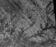
The Viking Orbiters caused a revolution in our ideas about water on Mars. Huge river valleys were found in many areas. They showed that floods of water broke through dams, carved deep valleys, eroded grooves into bedrock, and traveled thousands of kilometers. Areas of branched streams, in the southern hemisphere, suggested that rain once fell.[8][38][39]
The images below, some of the best from the Viking Orbiters, are mosaics of many small, high resolution images. Click on the images for more detail. Some of the pictures are labeled with place names.
 Streamlined Islands seen by Viking showed that large floods occurred on Mars. Image is located in Lunae Palus quadrangle. |
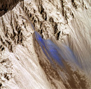
 Tear-drop shaped islands caused by flood waters from Maja Vallis, as seen by Viking Orbiter. Image is located in Oxia Palus quadrangle. The islands are formed in the ejecta of Lod Crater, Bok Crater, and Gold Crater. |
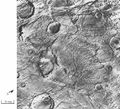
 Scour Patterns, located in Lunae Palus quadrangle, were produced by flowing water from Maja Vallis, which lies just to the left of this mosaic. Detail of flow around Dromore Crater is shown on the next image. |
 Great amounts of water were required to carry out the erosion shown in this Viking image. Image is located in Lunae Palus quadrangle. The erosion shaped the ejecta around Dromore Crater. |
|
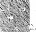
Waters from Vedra Vallis, Maumee Vallis, and Maja Valles went from Lunae Planum on the left, to Chryse Planitia on the right. Image is located in Lunae Palus quadrangle and was taken by Viking Orbiter. |
 Area around Northern Kasei Valles, showing relationships among Kasei Valles, Bahram Vallis, Vedra Vallis, Maumee Vallis, and Maja Valles. Map location is in Lunae Palus quadrangle and includes parts of Lunae Planum and Chryse Planitia. |
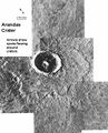 The ejecta from Arandas Crater acts like mud. It moves around small craters (indicated by arrows), instead of just falling down on them. Craters like this suggest that large amounts of frozen water were melted when the impact crater was produced. Image is located in Mare Acidalium quadrangle and was taken by Viking Orbiter. |
 This view of the flank of Alba Patera shows several chnnels/troughs. Some channels are associated with lava flows; others are probably caused by running water. A large trough or graben turns into a line of collapse pits. Image is located in Arcadia quadrangle and was taken by Viking Orbiter. |
 Branched channels in Thaumasia quadrangle, as seen by Viking Orbiter. Networks of channels like this are strong evidence for rain on Mars in the past. |
 The branched channels seen by Viking from orbit strongly suggested that it rained on Mars in the past. Image is located in Margaritifer Sinus quadrangle. |
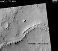
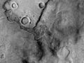
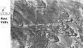 Ravi Vallis, as seen by Viking Orbiter. Ravi Vallis was probably formed when catastrophic floods came out of the ground to the right (chaotic terrain). Image located in Margaritifer Sinus quadrangle. |
Channels near Warrego Valles. These branched channels are strong evidence for flowing water on Mars, perhaps during a much warmer period. |
 Semeykin Crater Drainage. Click on image to see details of beautiful drainage system. Location is Ismenius Lacus quadrangle. |
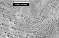
 Channels in Candor plateau, as seen by HiRISE. Location is Coprates quadrangle. Click on image to see many small, branched channels which are strong evidence for sustained precipitation. |
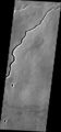
 Channels near the rim of Ius Chasma, as seen by HiRISE. The pattern and high density of these channels support precipitation as the source of the water. Location is Coprates quadrangle. |
The high resolution Mars Orbiter Camera on the Mars Global Surveyor has taken pictures which give much more detail about the history of liquid water on the surface of Mars. Despite the many giant flood channels and associated tree-like network of tributaries found on Mars there are no smaller scale structures that would indicate the origin of the flood waters. It has been suggested that weathering processes have denuded these indicating the river valleys are old features. Another theory about the formation of the ancient river valleys is that rather than floods, they were created by the slow seeping out of groundwater. This observation is supported by the sudden ending of the river networks in theatre shaped heads, rather than tapering ones. Also valleys are often discontinuous, small sections of uneroded land separating the parts of the river.[40]
On the other hand, evidence in favor of heavy or even catastrophic flooding is found in the giant ripples in the Athabasca Vallis [2].
Research, published Journal of Geophysical Research in June 2010, reported the detection of 40,000 river valleys on Mars, about four times the number of river valleys that have previously been identified by scientists.[41]
Higher resolution observations from spacecraft like Mars Global Surveyor also revealed at least a few hundred features along crater and canyon walls that appear similar to terrestrial seepage gullies.[42] The gullies tended to be Equator facing and in the highlands of the southern hemisphere, and all poleward of 30° latitude.[43] The researchers found no partially degraded (i.e. weathered) gullies and no superimposed impact craters, indicating that these are very young features.
 Group of gullies on north wall of crater that lies west of the crater Newton (41.3047 degrees south latitude, 192.89 east longitide). Image taken with Mars Global Surveyor under the public target program. |
 Crater wall inside Mariner Crater showing a large group of gullies, as seen by HiRISE. |
 Gullies with branches. |
 Group of deep gullies, as seen by HiRISE. |
Inverted relief
Some areas of Mars show inverted refief, where features that were once depressions, like streams, are now instead above the surface. It is believed that materials like large rocks were deposited in low-lying areas. Later, erosion (perhaps wind which can't move large rocks) removed much of the surface layers, but left behind the more resistant deposits. Other ways of making inverted relief might be lava flowing down a stream bed or materials being cemented by minerals dissolved in water. On Earth, materials cemented by silica are highly resistant to all kinds of erosional forces. Examples of inverted channels on Earth are found in the Cedar Mountain Formation near Green River, Utah. Inverted relief in the shape of streams are further evidence of water flowing on the Martian surface in past times.[44] Inverted relief in the form of stream channels suggest that the climate was different—much wetter—when the inverted channels were formed.
In an article published in January 2010, a large group of scientists endorsed the idea of searching for life in Miyamoto Crater because of inverted stream channels and minerals that indicated the past presence of water.[15][15][45]
Images of other examples of inverted terrain are shown below from various parts of Mars.
 Inverted Streams near Juventae Chasma, as seen by Mars Global Surveyor. These streams begin at the top of a ridge then run together. |
Inverted Channel with many branches in Syrtis Major quadrangle. |
 Inverted Stream Channels in Antoniadi Crater, as seen by HiRISE. Image in Syrtis Major quadrangle. |
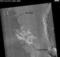
 Inverted Channel in Miyamoto Crater, as seen by HiRISE. Image is located in Margaritifer Sinus quadrangle. The scale bar is 500 meters long. |
Liquid water
 |
||
|
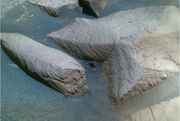
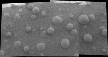
Mosaic shows some spherules partly embedded.
|
Photo of Microscopic rock forms indicating past signs of water, taken by Opportunity
|
Liquid water cannot exist on the surface of Mars with its present low atmospheric pressure, except at the lowest elevations for short periods.[46][47] Recently, there has been evidence to support the popular belief that liquid water flowed on the surface in the recent past, with the discovery of gully deposits that were not seen ten years ago.[48][49] There is some disagreement in the scientific community as to whether or not the new gully deposits were formed from liquid water. A paper, published in the January 2010 issue of Icarus, concluded that the observed deposits were probably dry flows that were started by a rockfall in steep regions.[50][51]
Among the findings from the Opportunity rover is the presence of hematite on Mars in the form of small spheres on the Meridiani Planum. The spheres are only a few millimetres in diameter and are believed to have formed as rock deposits under watery conditions billions of years ago. Other minerals have also been found containing forms of sulfur, iron or bromine such as jarosite. This and other evidence led a group of 50 scientists to conclude in the December 9, 2004 edition of the journal Science that "Liquid water was once intermittently present at the Martian surface at Meridiani, and at times it saturated the subsurface. Because liquid water is a key prerequisite for life, we infer conditions at Meridiani may have been habitable for some period of time in Martian history". Later studies suggested that this liquid water was actually acid because of the types of minerals found at the location[52][53]. On the opposite side of the planet the mineral goethite, which (unlike hematite) forms only in the presence of water, along with other evidence of water, has also been found by the Spirit rover in the "Columbia Hills".
On July 31, 2008, NASA announced that the Phoenix lander confirmed the presence of water ice on Mars,[54] as predicted on 2002 by the Mars Odyssey orbiter.
Studies have shown that various salts present in the Martian soil could act as a kind of antifreeze—keeping water liquid at temperatures far below its normal freezing point.[55][56] Some calculations suggest that tiny amounts of liquid water may be present for short periods of time (hours) in some locations.[57] Some researchers have calculated that when taking into consideration insolation and pressure factors that liquid water could exist in some areas for about 10% of the Martian year;[58] others estimate that water could be a liquid for only 2% of the year.[59] Either way, that may be enough liquid water to support some forms of hardy organisms. It may not take much liquid water for life; organisms have been found on Earth living on extremely thin layers of unfrozen water in below-freezing locations.[60] Research described in December 2009, showed that liquid water could form in the daytime inside of snow on Mars. As light heats ice, it may be warming up dust grains located inside. These grains would then store heat and form water by melting some of the ice. This process has already been observed in Antarctica. Enough water may be produced for physical, chemical, and biological processes.[61][62]
Polar ice caps
Both the northern polar cap (Planum Boreum) and the southern polar cap (Planum Australe) are believed to grow in thickness during the winter and partially sublime during the summer. Data obtained by the Mars Express satellite, made it possible in 2004 to confirm that the southern polar cap has an average of 3 kilometres (1.9 mi) thick slab of CO2 ice[63] with varying contents of frozen water, depending on its latitude; the polar cap is a mixture of 85% CO2 ice and 15% water ice.[64] The second part comprises steep slopes known as 'scarps', made almost entirely of water ice, that fall away from the polar cap to the surrounding plains.[64] The third part encompasses the vast permafrost fields that stretch for tens of kilometres away from the scarps.[64][65] NASA scientists calculate that the volume of water ice in the south polar ice cap, if melted, would be sufficient to cover the entire planetary surface to a depth of 11 metres.[66]
Research, published in January 2010 using HiRISE images, says that understanding the layers is more complicated than was formerly believed. The brightness of the layers does not just depend on the amount of dust. The angle of the sun together with the angle of the spacecraft greatly affect the brightness seen by the camera. This angle depends on factors such as the shape of the trough wall and its orientation. Furthermore, the roughness of the surface can greatly change the albedo (amount of reflected light). In addition, many times what one is seeing is not a real layer, but a fresh covering of frost. All of these factors are influenced by the wind which can erode surfaces. The HiRISE camera did not reveal layers that were thinner than those seen by the Mars Global Surveyor. However, it did see more detail within layers.[67]
Ice patches
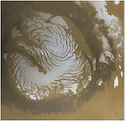
On July 28, 2005, the European Space Agency announced the existence of a crater partially filled with frozen water;[68] some then interpreted the discovery as an "ice lake".[69] Images of the crater, taken by the High Resolution Stereo Camera on board the European Space Agency's Mars Express spacecraft, clearly show a broad sheet of ice in the bottom of an unnamed crater located on Vastitas Borealis, a broad plain that covers much of Mars' far northern latitudes, at approximately 70.5° North and 103° East. The crater is 35 km wide and about 2 km deep.
The height difference between the crater floor and the surface of the water ice is about 200 metres. ESA scientists have attributed most of this height difference to sand dunes beneath the water ice, which are partially visible. While scientists do not refer to the patch as a "lake", the water ice patch is remarkable for its size and for being present throughout the year. Deposits of water ice and layers of frost have been found in many different locations on the planet.
Equatorial frozen sea
Surface features consistent with pack ice have been discovered in the southern Elysium Planitia. What appear to be plates of broken ice, ranging in size from 30 m to 30 km, are found in channels leading to a flooded area of approximately the same depth and width as the North Sea. The plates show signs of break up and rotation that clearly distinguish them from lava plates elsewhere on the surface of Mars. The source for the flood is thought to be the nearby geological fault Cerberus Fossae which spewed water as well as lava aged some 2 to 10 million years.[70]
Ancient coastline
A striking feature of the topography of Mars is the flat plains of the northern hemisphere. With the increasing amounts of data returning from the current set of orbiting probes, what seems to be an ancient shoreline several thousands of kilometres long has been discovered. Actually, two different shorelines have been proposed. One, the Arabia shoreline can be traced all around Mars except through the Tharsis volcanic region. The second, the Deuteronilus follows the Vastitas Borealis Formation. Some researchers do not agree that these formations are real shorelines.[71][72] One major problem with the conjectured 2 Ga old shoreline is that it is not flat — i.e. does not follow a line of constant gravitational potential. However a 2007 Nature article points out that this could be due to a change in distribution in Mars' mass, perhaps due to volcanic eruption or meteor impact — the Elysium volcanic province or the massive Utopia basin that is buried beneath the northern plains have been put forward as the most likely causes.[73] The Mars Ocean Hypothesis conjectures that the Vastitas Borealis basin was the site of a primordial ocean of liquid water 3.8 billion years ago.[74]
Geysers on Mars
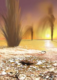
The seasonal frosting and defrosting of the southern ice cap results in the formation of spider-like radial channels carved between the ground and 1 meter thick ice. Then, sublimed CO2 increase pressure in their interior producing geyser-like eruptions of cold fluids often mixed with dark basaltic sand or mud.[75][76][77][78] This process is rapid, observed happening in the space of a few days, weeks or months, a growth rate rather unusual in geology - especially for Mars.
Several articles published in the January 2010 issue of Icarus,[51] tell of what has been learned about these gas driven jets using HiRISE on the Mars Reconnaissance Orbiter. So far, evidence supports an earlier model put forth by H. Kieffer.[79] Doctor Kiefer suggests that each spring, sunlight passes through a layer of CO2 ice, then heats the dark ground under the ice. The warm ice sublimates (goes directly from a solid to a gas) and builds up pressure. Eventually, the pressurized gas is released explosively or moves along to a weak spot. The gas takes dark material with it. Measurements suggest the dark matter that is released is in the form of silt-sized particles. The total amount of dust in all the spiders is huge. It has been calculated that the total amount of dust moved around each year is equal to 100 times the mass of dust in a global dust storm. Stereo images show that some channels grow larger as they go uphill—meaning gas is the eroding agent instead of a liquid.[80] In some areas, the jets appear to hug the ground, rather than shoot up straight like a geyser. Observations suggest that a single jet may erupt with at least 30 grams of material per second. However, it is possible that this amount may increase by several orders of magnitude.[81]
Glaciers and ice ages
Many large areas of Mars have been shaped by glaciers. Much of the area in high latitudes, especially the Ismenius Lacus quadrangle, is believed to still contain enormous amounts of water ice.[8][82] Recent evidence has led many planetary scientists to believe that water ice still exists as glaciers with a thin covering of insulating rock.[83][84][85][86][87] In March 2010, scientists released the results of a radar study of an area called Deuteronilus Mensae that found widespread evidence of ice lying beneath a few meters of rock debris.[88] Glaciers are believed to be associated with Fretted terrain, many volcanoes, and even some craters. Researchers have described glacial deposits on Hecates Tholus,[89] Arsia Mons,[90] Pavonis Mons,[91] and Olympus Mons.[92]
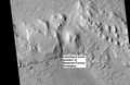
Ridges of debris on the surface of the glaciers indicate the direction of ice movement. The surface of some glaciers has a rough texture due to sublimation of buried ice. The ice goes directly into a gas (this process is called sublimation) and leaves behind an empty space. Overlying material then collapses into the void.[93] Glaciers are not pure ice; they contain dirt and rocks. At times, they dump their loads of material into ridges. Such ridges are called moraines. Some places on Mars have groups of ridges that are twisted around; this may have been due to more movement after the ridges were put into place. Sometimes chunks of ice fall from the glacier and get buried in the land surface. When they melt a more or less round hole remains.[94] On Earth we call these features kettles or kettle holes. Mendon Ponds Park in upstate NY has preserved several of these kettles. The picture from HiRISE below shows possible kettles in Moreux Crater.
Other pictures below show various features that appear to be connected with the existence of glaciers.
 Moreux Crater moraines and kettle holes, as seen by HIRISE. Location is Ismenius Lacus quadrangle. |
 Tributary Glacier, as seen by HiRISE. Location is Ismenius Lacus quadrangle. |
 Clanis and Hypsas Valles, as seen by HiRISE. Ridges are probably due to glacial flow. Ice is covered by a thin layer of rocks. Location is Ismenius Lacus quadrangle. |
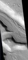
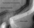 Niger Vallis with features typical of this latitude. Chevon pattern results from movement of ice-rich material. Click on image to see chevron pattern and mantle. Location is Hellas quadrangle. |
Many mid-latitude craters contain straight and/or curved ridges of material that resemble glacial moraines on the Earth. Moving ice carries rock material, then drops it as the ice disappears. On Mars, with its extremely thin atmosphere, ice does not usually melt. Ice sublimates, that is changes directly from a solid to a gas. As a result, the rock debris is just dropped; melt water is not produced, so remains of these glaciers do not appear the same as on the Earth. Various names have been applied to these ridged features. Depending on the author, they may be called arcuate ridges,[95] viscous flow features,[96] Martian flow features, or moraine-like ridges. Many, but not all, seem to be associated with gullies on the walls of craters and mantling material.[97]
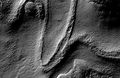
 Gullies and possible remains of old glaciers in a crater in Eridania quadrangle, north of the large crater Kepler. One suspected glacier, to the right, has the shape of a tongue. Image taken with Mars Global Surveyor. |
 Tongue-Shaped Glacier, as seen by Mars Global Surveyor. Location is Hellas quadrangle. |
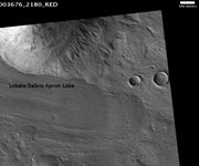
Lineated deposits are probably rock-covered glaciers which are found on the floors of some channels. Their surfaces have ridged and grooved materials that deflect around obstacles, similar to some glaciers on the Earth. Lineated floor deposits may be related to Lobate Debris Aprons, which have been proven to contain large amounts of ice by orbiting radar.[86][87][98]
For many years researchers believed that on Mars features called Lobate Debris Aprons looked like glacial flows. It was thought that ice existed under a layer of insulating rocks.[83][84][85] With new instrument readings, it has been confirmed that Lobate Debris Aprons contain almost pure ice that are covered with a layer of rocks.[86][87]
 Reull Vallis with lineated floor deposits. Click on image to see relationship to other features. Floor deposits are believed to be formed from ice movement. Location is Hellas quadrangle. |
 Coloe Fossae Lineated Valley Fill, as seen by HiRISE. Scale bar is 500 meters long. Location is Ismenius Lacus quadrangle. |
Ice ages on Mars are far different than the ones that our Earth experiences. Ice ages on Mars, that is when ice accumulates, occur during warmer periods.[99] During a Martian ice age, the poles get warmer. Water ice leaves the ice caps and is deposited in mid latitudes. The moisture from the ice caps travels to lower latitudes as deposits of frost or snow mixed generously with dust. The atmosphere of Mars contains a great deal of fine dust particles. Water vapor condenses on these particles, which then fall down to the ground due to the additional weight of the water coating. When ice at the top of the mantling layer returns to the atmosphere, it leaves behind dust, that serves to insulate the remaining ice.[100] The total volume of water removed is about a few percent of the ice caps or enough to cover the entire surface of the planet under one meter of water. Much of this moisture from the ice caps results in a thick smooth mantle that is thought to be a mixture of ice and dust.[101][102][103] This ice-rich mantle, a few yards thick, smoothes the land. But in places it displays a bumpy texture, resembling the surface of a basketball. Because there are few craters on this mantle, the mantle is relatively young. It is believed that this mantle was put in place during a relatively recent ice age. The mantle covers areas to the equivalent latitude of Saudi Arabia and the southern United States.
The images below, all taken with HiRISE show a variety of views of this smooth mantle.
 Ptolemaeus Crater Rim. Click on image to see excellent view of mantle deposit. Location is Phaethontis quadrangle. |
 Atlantis Chaos. Click on image to see mantle covering and possible gullies. The two images are different parts of the original image. They have different scales. Location is Phaethontis quadrangle. |
 Dissected mantle with layers. Location is Noachis quadrangle. |
Ice ages are driven by changes in Mars's orbit and tilt. Orbital calculations show that Mars wobbles on its axis far more than Earth. Earth is stabilized by its proportionally large moon, so it only wobbles a few degrees. Mars, in contrast, may change its tilt by tens of degrees. .[104] Its poles get much more direct sunlight at times, which causes the ice caps to warm and become smaller as ice sublimes. Adding to the variability of the climate, the eccentricity of the orbit of Mars changes twice as much as Earth's eccentricity. Computer simulations have shown that a 45° tilt of the Martian axis would result in ice accumulation in areas that display glacial landforms.[105] A 2008 study provided evidence for multiple glacial phases during Late Amazonian glaciation at the dichotomy boundary on Mars.[106]
Volcanism on Mars
Over half of the surface of Mars is covered by material from volcanoes. Both lava flows and explosive ash eruptions have occurred on Mars in the past.[107] Lava flows often built large shield volcanoes with shallow-sloping sides. Mars has the largest shield volcanoes in the Solar System. It also has a wide range of other volcanic features. These include large volcanic cones, unusual patera structures, volcanic plains, and a number of other smaller features. There are less than 20 named volcanoes on Mars, and only 5 of these are giant shields.[108] Lava eruptions on the Red Planet may have been unbelievable compared to what we see on the Earth. Research, published in January 2010, described the discovery of a vast single lava flow, the size of the state of Oregon, that "was put in place turbulently over the span of several weeks at most."[109] This flow, near Athabasca Valles, is the youngest lava flow on Mars. It is thought to be of Late Amazonian Age.[110]
 Lava flow, as seen by THEMIS. Note the shape of the edges |
 Lava flow located in the Elysium quadrangle. There are many lava flows in Elysium. In this one, the lava flowed toward the upper right. Image taken by Mars Global Surveyor. |
 Lava flows in Elysium as seen by HiRISE. Top part shows lava that solidified on the top then crumpled as lava still moved. |
 Lava flow and crater ejecta, as seen by HiRISE. Impact pentrated into light-toned material then spread it on darker surface. Scale bar is 500 meters long. |
Locations of major volcanoes
Volcanism occurred in two main regions, Tharsis and Elysium Planitia. Tharsis contains three large shield volcanoes, Ascraeus Mons, Pavonis Mons and Arsia Mons but also the tallest mountain in the Solar System Olympus Mons and the largest (by area), an atypical old volcano Alba Patera. Elysium Planitia also has three huge shield volcanoes, Hecates Tholus, Elysium Mons and Albor Tholus. The tallest volcano in the Solar System, Olympus Mons, lies on the northwestern flank of the enormous Tharsis volcanic plateau. The Elysium quadrangle contains the volcanoes Elysium Mons and Albor Tholus. Much of this area is covered with lava flows. Sometimes when lava flows the top cools quickly forming a solid crust. However, the lava below often still flows, this action breaks up the top layer making it very rough.[111] Such rough flow is called aa.
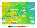
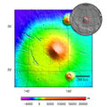
 Olympus Mons Region. Map shows locations of volcanoes of Tharsis. Click on image for more details. Location is Coprates quadrangle. |
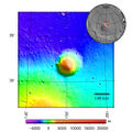
 Elysium Mons, as seen with MOLA. Elevations shown by different colors. |
 Hecates Tholus, as seen by Mars Global Surveyor. |
 Hecates Tholus topography. |
Without a doubt, the most easily seen feature on Mars is Syrtis Major. Syrtis Major is a Hesperian age shield volcano on Mars. It is 1100 km in diameter and 1 km high. It has two calderas, Meroe Patera and Nili Patera. Studies involving the regional gravity field suggest a solidified magma chamber at least 5 km thick lies under the surface.[112][113]
Did impacts cause the volcanoes?
The location of some Martian volcanoes may be due to giant impacts. One region of volcanoes, called the "Circum-Hellas volcanic province", has old, flat volcanoes. These volcanoes may have been caused by the great impact that produced the Hellas impact crater, the deepest crater on Mars.[114] Five volcanoes line up near rings thought to be caused by the impact.[115] They are Hadriaca Patera, Amphritrites Patera, Tyrrhena Patera, Peneus Patera, and Pityusa Patera.[116] Although they are not very high, some cover large areas; Amphritrites Patera covers a larger area than Olympus Mons. The huge Hellas event may have resulted in another large volcano when its seismic waves were focused to the exact opposite side of the planet. The force of the waves may have weaken the crust and allowed Alba Patra to form.[117][118] Though Alba Patera is not very tall, it does reign as the volcano with the largest area in the entire Solar System.
Igneous rocks
Igneous rocks are produced by volcanic processes. Syrtis Major, a large volcano near the equator, is of great interest to geologists because several types of igneous rocks were discovered there with orbiting spacecraft. Besides basalt, dacite and granite have been found there. Dacite originates under volcanoes in magma chambers. Dacites form at the top of the chamber, after the heavy minerals (olivine and pyroxene) containing iron and magnesium have settled to the bottom. Granite is formed by an even more complex process.[119] Some areas of Syrtis Major contain large amounts of the mineral olivine. Many igneous rocks contain olivine. Olivine turns into other minerals very rapidly in the presence of water, so finding a high abundance of olivine is a way to map the driest parts of Mars.[120]
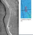
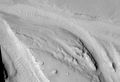
Dikes
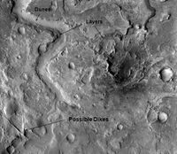
Some crater floors in the Syrtis Major area show elongated ridges in a lattice-like pattern. Such patterns are typical of faults and breccias dikes formed as a result of an impact. Dikes are often formed when hot materials flow through cracks in the crust. Sometimes dikes are formed primarily of molten rock which eventually cools and turns into erosion-resistant rocks. Ridges are found where there has been enhanced erosion because erosion removes all, but the most resistant materials. Pictures on this page show examples of these dikes. Some ridges may have formed from water moving along faults. The water often carries minerals that serve to cement rock materials thus making them harder. Later when the whole area undergoes erosion ridges will remain because they are more resistant to erosion.[121] This discovery may be of great importance for future colonization of Mars because these types of faults and breccias dikes on earth are associated with key mineral resources. Perhaps, when people live on Mars these areas will be mined, as they are on earth.[122]
Possible plate tectonics
Plate tectonics on Mars has been a controversial idea. For many years most scientists rejected the idea. However, some observations have caused researchers to revisit the notion. Pavonis Mons is the middle of three volcanoes (collectively known as Tharsis Montes) on the Tharsis bulge near the equator of the planet Mars. The other Tharsis volcanoes are Ascraeus Mons and Arsia Mons. The three Tharsis Montes, together with some smaller volcanoes to the north form a straight line. This arrangement suggests that they were formed by a crustal plate moving over a hot spot. Such an arrangement exists in the Earth's Pacific Ocean, especially with the Hawaiian Islands. The Hawaiian Islands are in a straight line, with the youngest in the south and the oldest in the north. So geologists believe the plate is moving while a plume of hot magma rises, then punches through the crust to produce volcanic mountains. However, the largest volcano on the planet, Olympus Mons, is thought to have formed when the plates were not moving. Olympus Mons may have formed just after the plate motion stopped. The mare-like plains on Mars are roughly 3 to 3.5 billion years old.[108] The giant shield volcanoes are younger, formed between 1 and 2 billion years ago. The youngest lava flows on Olympus Mons are only 20 to 200 million years old.[123]
Norman H. Sleep, professor of geophysics at Stanford University, spoke December 8, 2009 at the American Geophysical Union meeting in San Francisco; Sleep described how the three volcanoes that form a line along the Tharsis Ridge may be extinct island arc volcanoes, like the Japanese Island chain.[124]
Besides the line of volcanoes, there is other evidence of plate tectonics on Mars. The Mars Global Surveyor (MGS) discovered magnetic stripes in the crust of Mars, especially in the Phaethontis and Eridania quadrangles. The magnetometer on MGS discovered 100 km wide stripes of magnetized crust running roughly parallel for up to 2000 km. These stripes alternate in polarity with the north magnetic pole of one pointing up from the surface and the north magnetic pole of the next pointing down. When similar stripes were discovered on Earth in the 1960s, they were taken as evidence of plate tectonics. However, there are some differences, between the magnetic stripes on Earth and those on Mars. The Martian stripes are wider, much more strongly magnetized, and do not appear to spread out from a middle crustal spreading zone. Because the area with the magnetic stripes is about 4 billion years old, it is believed that the global magnetic field probably lasted for only the first few hundred million years of Mars' life. At that time the temperature of the molten iron in the planet's core might have been high enough to mix it into a magnetic dynamo. Younger rock does not show any stripes. When molten rock containing magnetic material, such as hematite (Fe2O3), cools and solidifies in the presence of a magnetic field, it becomes magnetized and takes on the polarity of the background field. This magnetism is lost only if the rock is subsequently heated above the Curie temperature, which is 770 degrees C for pure iron, but lower for oxides such as hematite (ca. 650) or magnetite (ca. 580).[125] The magnetism left in rocks is a record of the magnetic field when the rock solidified.[126]
Volcano interactions with ice
Large amounts of water ice are believed to be present under the surface of Mars. Some channels lie near volcanic areas. When hot subsurface molten rock comes close to this ice, large amounts of liquid water and mud may be formed. Hrad Valles in the Cebrenia quadrangle is close to Elysium Mons, a large volcano, and may have supplied water to create the channel. Hrad Valles is pictured on this page.[127]
 Hrad Valles may have been formed when the large Elysium Mons volcanic complex melted ground ice, as seen by THEMIS. |
 Streamlined islands in Hrad Valles, as seen by HiRISE. |
 Cones in Athabasca Vallis, as seen by HiRISE. Cones were formed from lava interacting with ice. Larger cones in upper image were produced when water/steam forced its way through thicker layer of lava. Difference between highest elevation (red) to lowest (dark blue) is 170 m (560 ft). |
 Rootless Cones, as seen by HiRISE. The chains of rings are interpreted to be caused by crust moving over a source of steam. The steam was produced by lava interacting with water ice. |
Volcanoes Changed the Climate
Some scientists maintain that the great mass of the Tharsis volcanoes has had a major influence on the climate of Mars. Erupting volcanoes give off great amounts of gas. The gases are usually water vapor and carbon dioxide. Estimates put the amount of gas released to the atmosphere from Martian volcanoes as enough to make the atmosphere thicker than the Earth's. In addition, the water vapor from the volcanoes could have made enough water to place all of Mars under 120 meters of water. Of course, carbon dioxide is a greenhouse gas. It raises the temperature of a planet by trapping heat in the form of infrared radiation. So Tharsis volcanoes could have made Mars Earth-like in the past. Mars may have once had a much thicker and warmer atmosphere, and oceans and/or lakes may have been present.[128]
Lava Channels and Tubes
Lava flows can form a lava tube, when exposed upper layers of lava cool and solidify to form a roof, while the lava continues flowing. Often, when all the remaining lava leaves the tube, the roof collapses, making a channel.[129] These features are found on Mars. Some can be seen around Pavonis Mons, in the picture below. Lava Channels on the flank of the volcano Pavonis Mons are pictured below in a picture from Mars Odyssey THEMIS. Lava flows often have a lobate appearance at the edges.
 Ituxi Vallis, as seen by THEMIS. Ituxi Vallis is a lava channel that lies east of Elysium Mons. |
 Collapsed lava tubes. Some straight troughs (grabens) crosscut the lava channels. Picture taken by THEMIS. Location is Phoenicis Lacus quadrangle. |
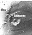
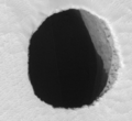
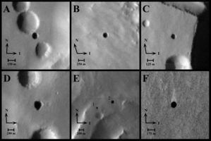
NASA scientists studying pictures from the Odyssey spacecraft have spotted what might be seven caves on the flanks of the Arsia Mons volcano on Mars. The pit entrances measure from 100 to 252 metres (330 to 827 ft) wide and they are believed to be at least 73 to 96 metres (240 to 315 ft) deep. See image below: the pits have been informally named (A) Dena, (B) Chloe, (C) Wendy, (D) Annie, (E) Abby (left) and Nikki, and (F) Jeanne. Because light did not reach the floor of most of the pits, it is likely that they extend much deeper than these lower estimates. Dena's floor was observed and found to be 130m deep.[130] Further investigation suggested that these were not necessarily lava tube "skylights"[131] Review of images has resulted in yet more discoveries of deep pits.[132]
 A cave on Mars ("Jeanne") as seen by the Mars Reconnaissance Orbiter. |
 HiRISE closeup of Jeanne showing afternoon illumination of the east wall of the shaft. |
 THEMIS image of cave entrances on Mars. |
It's been suggested that human explorers on Mars could use lava tubes as shelters. The caves may be the only natural structures offering protection from the micrometeoroids, UV radiation, solar flares and high energy particles that bombard the planet's surface.[133]
Glaciers on Volcanoes
Using new MGS and Odyssey data, combined with recent developments in the study of cold-based glaciers, scientists believe glaciers once existed and still exist on some volcanoes. The evidence for this are concentric ridges (these are moraines dropped by the glacier), a knobby area (caused by ice sublimating), and a smooth section that flows over other deposits (debris-covered glacial ice). The ice could have been deposited when the tilt of Mars changed the climate, thereby causing more moisture to be present in the atmosphere. Studies suggest the glaciation happened in the Late Amazonian period, the last period (that is the latest) in Mars history. Also, multiple stages of glaciations probably occurred.[134] The ice present today represents one more resource for the possible, future colonization of the planet. Researchers have described glacial deposits on Hecates Tholus,[89] Arisia Mons,[90] Pavonis Mons,[91] and Olympus Mons.[92]
Lava Flows Created Canyons
A team of scientists argued, in a study dated March 2010, that at least some of the canyons and supposed riverbeds on Mars were created by lava flows eroding rock. They used a variety of images from orbiting spacecraft to examine the full length of a known lava channel. They then studied a lava channel on Earth's Mauna Loa on the Big Island of Hawaii. This lava flow from 1859 produced most of the same features on Mars that were thought to only be made by running water. They found terraced walls on the insides of channels, channels that go out and just disappear, channels that cut back into the main one, and vertical walls 9 meters high.
Common Surface Features
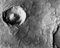
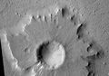
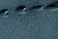
Impact crater morphology
Crater morphology provides information about the physical structure and composition of the surface. Impact craters allow us to look deep below the surface and into Mars geological past. Lobate ejecta blankets (pictured left) and central pit craters are common on Mars but uncommon on the Moon, which may indicate the presence of near-surface volatiles (ice and water) on Mars. Degraded impact structures record variations in volcanic, fluvial, and eolian activity.[135]
The Yuty crater is an example of a Rampart crater so called because of the rampart-like edge of the ejecta. In the Yuty crater the ejecta competely covers an older crater at its side, showing that the ejected material is just a thin layer.[136]
The largest unambiguous impact crater is the Hellas Basin in the southern hemisphere. However, it appears that the Borealis Basin, covering most of the low-lying northern hemisphere, is also an impact crater.[3]
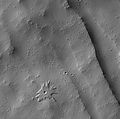
Pedestal craters are quite common on Mars. Pedestal craters are craters with their ejecta sitting above the surrounding terrain. Their ejecta forms raised platforms. They form when an impact crater ejects material which forms an erosion resistant layer, thus causing the immediate area to erode more slowly than the rest of the region. Some pedestals have been accurately measured to be hundreds of meters above the surrounding area. This means that hundreds of meters of material were eroded away. The result is that both the crater and its ejecta blanket stand above the surroundings. Pedestal craters were first observed during the Mariner missions.[137][138][139]
 Yuty impact crater with typical rampart ejecta. |
 Tikonravev Crater floor in Arabia quadrangle, as seen by Mars Global Surveyor |
 Secchi Crater floor in Hellas quadrangle, as seen by HiRISE. Click on image to see dust devil tracks and a pedestal crater. |
 Pedestal crater in Amazonis quadrangle with dark streaks, as seen by HiRISE. |
 Biblis Patera Pedestal crater, as seen by HiRISE. |
 The eastern (west-facing) side of an impact crater in the mid-latitudes of the northern hemisphere. |
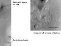
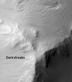
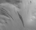
Slope streaks
A new phenomenon known as slope streaks has been uncovered by the HiRISE camera on the Mars Reconnaissance Orbiter. These features appear on crater walls and other slopes and are thin but many hundreds of metres long. The streaks have been observed to grow slowly over the course of a year or so, always beginning at a point source. Newly formed streaks are dark in colour but fade as they age until white. The cause is unknown, but theories range from dry dust avalanches (the favoured theory) to brine seepage.[140]
Examples of Dark Slope Streaks from various parts of Mars are shown below. Click on image to get a better view.
|
Tikonravev Crater floor in Arabia quadrangle, as seen by Mars Global Surveyor. Click on image to see dark slope streaks and layers. |
Pedestal crater in Amazonis quadrangle with dark streaks, as seen by HiRISE. |
 Nicholson crater mound with dark streaks, as seen by HiRISE. |
 Tharsis Tholus block in the Tharsis quadrangle, as seen by HiRISE. Block probably tumbled down Tharsis Tholus which is just off to the right. |
 Ceraunius Fossae in Tharsis quadrangle, as seen by HiRISE. |
 Dark streaks in Diacria quadrangle, as seen by Mars Global Surveyor. |
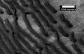
Dust Devil Tracks
Many areas on Mars experience the passage of giant dust devils. A thin coating of fine bright dust covers most of the martain surface. When a dust devil goes by it blows away the coating and exposes the underlying dark surface. These tracks can make some strange and beautiful patterns. In addition, the patterns change frequently. These dust devils have been seen from the ground and high overhead from orbit. They have even blown the dust off of the solar panels of the two Rovers on Mars, thereby greatly extending their lives.[141] The twin Rovers were designed to last for 3 months, instead they have lasted six years and are still going. The pattern of the tracks have been shown to change every few months.[142]
 Kepler (Martian crater) showing dust devil tracks, as seen by Mars Global Surveyor. |
 Pattern of large and small tracks made by giant dust devils. |
 Russell Crater Dust Devil Changes in Noachis quadrangle, as seen by HiRISE. Click on imnage to see changes in dust devil tracks in just 3 months. |
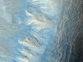
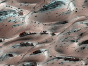
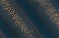
Sand Dunes
Many locations on Mars have sand dunes. The surface is billions of years old in places, so there has been plenty of time for rocks to be broken down into sand. Many dunes are black because they are derived from the dark volcanic rock basalt. Dunes on Mars can be among the most beautiful sights in the universe. Sometimes they are covered with frost.
 Dark dunes (probably basalt) which form a dark spot in Noachis. Picture from Mars Global Surveyor. |
 Wide view of dunes in Noachis, as seen by HiRISE. |
 Close-up View of dunes in previous image, as seen by HiRISE. Note how sand barely covers some boulders. |
 Rabe Crater Floor, as seen by HiRISE. Click on image to see layers. Dark sand that made the dunes was probably blown in from elsewhere. |
 Barchan sand dunes in the Hellespontus region, as seen by HiRISE. The horns point in the downwind direction so winds that formed these dunes came out of the west. |
 Proctor Crater Ripples and Dunes, as seen by HiRISE. |
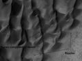
Medusae Fossae Formation
The Medusae Fossae Formation is a soft, easily eroded deposit that extends for nearly 1,000 km along the equator of Mars. Sometimes, the formation appears as a smooth and gently undulating surface, however in places it is wind-sculpted into ridges and grooves.[143] Radar imaging has suggested that the region may contain either extremely porous rock (for example volcanic ash) or deep layers of glacier-like ice deposits amounting to about the same quantity as is stored in Mars' south polar cap.[144][145]
The lower portion (member) of Medusae Fossae Formation contains many patterns and shapes that are thought to be the remains of streams. It is believed that streams formed valleys that were filled and became resistant to erosion by cementaion of minerals or by the gathering of a coarse covering layer. These inverted stream beds are sometimes called sinuus ridges or raised curvilinear features. They may be a kilometer or so in length. Their height ranges from a meter to greater than 10 meters, while the width of the narrow ones is less than 10 meters.[15][146]
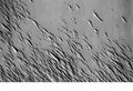
The surface of the formation has been eroded by the wind into a series of linear ridges called yardangs. These ridges generally point in direction of the prevailing winds that carved them, and demonstrate the erosive power of martian winds. The easily eroded nature of the Medusae Fossae Formation suggests that it is composed of weakly cemented particles, and was most likely formed by the deposition of wind-blown dust or volcanic ash. Layers are seen in parts of the formation. A resistant caprock on the top of yardings has been observed in Viking,[147] Mars Global Surveyor,[148] and HiRISE photos.[149] Very few impact craters are visible throughout the area so the surface is relatively young.[150]
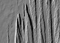
 Medusae Fossae Formation as seen with Mars Odyssey's THEMIS. Notice elongated formations called yardangs. |
 Medusae Fossae Formation as seen with HiRISE. Image is located in the Aeolis quadrangle. |
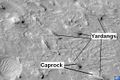 Yardangs in Medusae Fossae Formation with caprock labeled, as seen by HiRISE. Location is Aeolis quadrangle. |
 Layers in lower member of Medusae Fossae Formation, as seen by HiRISE. Location is Aeolis quadrangle. |
Fretted Terrain
Fretted Terrain is a type of surface feature common to certain areas of Mars and discovered in Mariner 9 images. It lies between two different surfaces. The surface of Mars can be divided into two parts: low, young, uncratered plains that cover most of the northern hemisphere, and high-standing, old, heavily cratered areas that cover the southern hemisphere, as well as part of the northern hemisphere. Between these two zones is the fretted terrain, containing a complicated mix of cliffs, mesas, buttes, straight-walled and sinuous canyons. Fretted terrain contains smooth, flat lowlands along with steep cliffs. The scarps or cliffs are usually 1 to 2 km high. Channels in the area have wide, flat floors and steep walls.[151] Fretted terrain is most common in northern Arabia, between latitudes 30°N and 50°N and longitudes 270°W and 360°W.[152] Parts of the fretted terrain are called Deuteronilus Mensae and Protonilus Mensae.
In fretted terrain the land seems to transition from narrow straight valleys to isolated measas. Most of the measa are surrounded by forms that have been called a variety of names: circum-mesa aprons, debris aprons, rock glaciers, and Lobate Debris Aprons.[153] At first they appeared to resemble rock glaciers on Earth. But scientists could not be sure. Eventually, proof of their true nature was discovered by radar studies with the Mars Reconnaissance Orbiter showed that they contain pure water ice covered with a thin layer of rocks that insulated the ice.[83][86][87][98][154][155]
Besides rock covered glaciers around mesas, the region has many steep-walled valleys with lineations—ridges and grooves—on their floors. The material comprising these valley floors is called lineated valley fill. In some of the best images taken by the Viking Orbiters, some of the valley fill appeared to resemble alpine glaciers on Earth. Given this similarity, some scientists assumed that the lineations on these valley floors might have formed by flow of ice in (and perhaps through) these canyons and valleys. Today it is generally agreed that glacial flow caused the lineations.
 Fretted terrain of Ismenius Lacus showing flat floored valleys and cliffs. Photo taken with Mars Orbiter Camera (MOC)on the Mars Global Surveyor. |
 Enlargement of the photo on the left showing cliff. Photo taken with high resolution camera of Mars Global Surveyor (MGS). |
 Lobate Debris Apron in Phlegra Montes, as seen by HiRISE. The debris apron is probably mostly ice with a thin covering of rock debris, so it could be a source of water for future Martian colonists. Image from the Cebrenia quadrangle. Scale bar is 500 meters long. |
Reull Vallis with lineated floor deposits, as seen by THEMIS. Image located in Hellas quadrangle. Click on image to see relationship to other features. |
 Fretted Terrain near Reull Vallis, as seen by HiRISE. |
 Close-up of Fretted Terrain near Reull Vallis, as seen by HiRISE. This area would be a challenge to walk across. |
Chaos Terrain
Chaos terrain is believed to be associated with the release of huge amounts of water. The Chaotic features may have collapsed when water came out of the surface. Martian rivers begin with a Chaos region. A chaotic region can be recognized by a rat's nest of mesas, buttes, and hills, chopped through with valleys which in places look almost patterned. Some parts of this chaotic area have not collapsed completely—they are still formed into large mesas, so they may still contain water ice.[156] Chaotic terrain occurs in numerous locations on Mars, and always gives the strong impression that something abruptly disturbed the ground. Chaos regions formed long ago. By counting craters (more craters in any given area means an older surface) and by studying the valleys' relations with other geological features, scientists have concluded the channels formed 2.0 to 3.8 billion years ago.[157]
 Huge canyons in Aureum Chaos, as seen by THEMIS. Gullies are rare at this latitude. Image from Margaritifer Sinus quadrangle. |
 Iani Chaos, as seen by THEMIS. Sand from eroding mesas is covering brighter floor material. Click on image to see relationship of Iani Chaos to other local features. Image from Margaritifer Sinus quadrangle. |
 Erosion in Aram Chaos, as seen by THEMIS. Image in Oxia Palus quadrangle. |
 Blocks in Aram showing possible source of water, as seen by THEMIS. Image in Oxia Palus quadrangle. |
 Light colored layers in Eos Chaos, as seen by HiRISE. |
 Gorgonum Chaos as seen by Mars Reconnaisance Orbiter HiRISE. Image is 4 km wide. Image in Phaethontis quadrangle. |
 Ister Chaos, as seen by HiRISE. |
 Close-up of Ister Chaos, as seen by HiRISE. |
Scalloped Topography
Scalloped topography is common in the mid-latitudes of Mars, between 45° and 60° north and south. It is particularly prominent in the region of Utopia Planitia[158][159] in the northern hemisphere and in the region of Peneus and Amphitrites Patera[160][161] in the southern hemisphere. Such topography consists of shallow, rimless depressions with scalloped edges, commonly referred to as "scalloped depressions" or simply "scallops". Scalloped depressions can be isolated or clustered and sometimes seem to coalesce. A typical scalloped depression displays a gentle equator-facing slope and a steeper pole-facing scarp. This topographic asymmetry is probably due to differences in insolation. Scalloped depressions are believed to form from the removal of subsurface material, possibly interstitial ice, by sublimation (direct transition of a material from the solid to the gas phase with no intermediate liquid stage). This process may still be happening at present.[162]
 Scalloped Terrain at Peneus Patera, as seen by HiRISE. Scalloped terrain is quite common in some areas of Mars. Image is from the Noachis quadrangle. |
 Periglacial Forms in Utopia, as seen by HiRISE. Click on image to see patterned ground and Scalloped Topography. Image in Casius quadrangle. |
 Mad Vallis, as seen by HiRISE. Picture on right is an enlargement of part of the other picture. Click on image to see scalloped terrain. Image in Hellas quadrangle. |
 Stages in scalop formation, as seen by HiRISE. Location is Hellas quadrangle. |
Major Geological Events
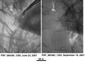
On February 19, 2008 a geologic event was captured by the HiRISE camera on the Mars Reconnaissance Orbiter. Images which captured a spectacular avalanche thought to be fine grained ice, dust and large blocks are shown to have fallen from a 2,300-foot (700 m) high cliff. Evidence of the avalanche are shown by the dust clouds rising from the cliff afterwards.[163] Such geological events are theorized to be the cause of geologic patterns known as slope streaks.
Mars Avalanche Photo Gallery
 Image of the February 19, 2008 Mars avalanche captured by the Mars Reconnaissance Orbiter. |
 Closer shot of the avalanche. |
 Dust clouds rise above the 2,300-foot (700 m) deep cliff. |
 A photo with scale demonstrates the size of the avalanche. |
See also
|
|
References
- ↑ Yeomans, Donald K. (2006-07-13). "HORIZONS System". NASA JPL. http://ssd.jpl.nasa.gov/?horizons. Retrieved 2007-08-08. — At the site, go to the "web interface" then select "Ephemeris Type: ELEMENTS", "Target Body: Mars" and "Center: Sun".
- ↑ 2.0 2.1 Seidelmann, P. Kenneth; Archinal, B. A.; A’hearn, M. F.; et al. (2007). "Report of the IAU/IAGWorking Group on cartographic coordinates and rotational elements: 2006". Celestial Mechanics and Dynamical Astronomy 90: 155–180. doi:10.1007/s10569-007-9072-y. http://adsabs.harvard.edu/doi/10.1007/s10569-007-9072-y. Retrieved 2007-08-28.
- ↑ 3.0 3.1 "Mars: Facts & Figures". NASA. http://solarsystem.jpl.nasa.gov/planets/profile.cfm?Object=Mars&Display=Facts&System=Metric. Retrieved 2007-03-06.
- ↑ 4.0 4.1 4.2 David R. Williams (September 1, 2004). "Mars Fact Sheet". National Space Science Data Center. NASA. http://nssdc.gsfc.nasa.gov/planetary/factsheet/marsfact.html. Retrieved 2006-06-24.
- ↑ Greeley, R. (1992) Planetary Landscapes, 2nd ed.; Chapman & Hall: New York, p. 1.
- ↑ Quinion, M. (1996). World Wide Words Website, http://www.worldwidewords.org/turnsofphrase/tp-are1.htm.
- ↑ Clark, B. et al. 1976. Inorganic Analysis of Martian Samples at the Viking Landing Sites. Science: 194. 1283-1288.
- ↑ 8.0 8.1 8.2 8.3 ISBN 0-8165-1257-4
- ↑ Caplinger, Mike. "Determining the age of surfaces on Mars". Archived from the original on February 19, 2007. http://web.archive.org/web/20070219192450/http%3A//www.msss.com/http/ps/age2.html. Retrieved 2007-03-02.
- ↑ Elizabeth R. Fuller, James W. Head III "Amazonis Planitia: The role of geologically recent volcanism and sedimentation in the formation of the smoothest plains on Mars"
- ↑ Williams, Chris. "Probe reveals three ages of Mars". http://www.theregister.co.uk/2006/04/21/three_mars_eras/. Retrieved 2007-03-02.
- ↑ Bibring, Jean-Pierre; Langevin, Y; Mustard, JF; Poulet, F; Arvidson, R; Gendrin, A; Gondet, B; Mangold, N et al. (2006). "Global Mineralogical and Aqueous Mars History Derived from OMEGA/Mars Express Data". Science 312 (5772): 400–404. doi:10.1126/science.1122659. PMID 16627738.
- ↑ Linda M.V. Martel. "Pretty Green Mineral -- Pretty Dry Mars?". psrd.hawaii.edu. http://www.psrd.hawaii.edu/Nov03/olivine.html. Retrieved 2007-02-23.
- ↑ Weltz, C. et aL. 2010. Mars Reconnaissance Orbiter observations of light-toned layered deposits and associated fluvial landforms on the plateus adjacent to Valles Marineris. Icarus: 205. 73-102.
- ↑ 15.0 15.1 15.2 15.3 www.sciencedirect.com/science/journal/00191035
- ↑ McSween, Jr., H. 1985. SNC Meteorites: Clues to Martian Petrologic Evolution? Reviews of Geophysics: 23. 391-416
- ↑ Farmer, J. and D. Des Marais. 1999. Exploring for a record of ancient Martian life. Journal of Geophysical Letters: 104. 26,977-26,995
- ↑ Murchie, S et al. 2009. A synthesis of Martian aqueous mineralogy after 1 Mars year of observations from the Mars Reconnaissance Orbiter. Journal of Geophysical Research: 114. E00D06.
- ↑ Squyres, S. et al. 2004. In Situ Evidence for an Ancient Aqueous Environment at Meridiani Planum, Mars. Science: 306: 1709-1714.
- ↑ Squyres, S. eta al. 2008. Science: 320. 1063-1067
- ↑ 21.0 21.1 "NASA Mars Page". Volcanology of Mars. Archived from the original on September 29, 2006. http://web.archive.org/web/20060929042954/http%3A//erc.arc.nasa.gov/MarsVolc/basalt.htm. Retrieved June 13, 2006.
- ↑ 22.0 22.1 Peplow, Mark (2004-05-06). "How Mars got its rust". Nature. doi:10.1038/news040503-6. http://www.nature.com/news/2004/040503/full/news040503-6.html. Retrieved 2006-04-18.
- ↑ W. V. Boynton, D. W. Ming, S. P. Kounaves, S. M. Young, R. E. Arvidson, M. H. Hecht, J. Hoffman, D. K. Hamara1, R. C. Quinn, P. Smith, B. Sutter, D. C. Catling, and R. V. Morris, "Evidence for Calcium Carbonate at the Mars Phoenix Landing Site", Science, 2009, 325, 61-64
- ↑ R.V. Morris, S.W. Ruff, R. Gellert, D.W. Ming, R.E. Arvidson, B.C. Clark, D.C. Golden, K. Siebach, G. Klingelhöfer, C. Schröder, I. Fleischer, A.S. Yen, S.W. Squyres,
- ↑ NASA Mars Global Surveyor
- ↑ 26.0 26.1 Arkani-Hamed, Jafar; Boutin, Daniel (July 20–25, 2003). "Polar Wander of Mars: Evidence from Magnetic Anomalies" (PDF). Sixth International Conference on Mars. Pasadena, California: Dordrecht, D. Reidel Publishing Co.. http://www.lpi.usra.edu/meetings/sixthmars2003/pdf/3051.pdf. Retrieved 2007-03-02.
- ↑ "New Map Provides More Evidence Mars Once Like Earth" - Oct. 12, 2005 Goddard Space Flight Center Press release. URL accessed March 17, 2006.
- ↑ Arkani-Hamed, Jafar; Boutin, Daniel (March 2004), [doi:10.1029/2003JE002229 Paleomagnetic poles of Mars: Revisited], Pasadena, California, doi:10.1029/2003JE002229
- ↑ "The Solar Wind at Mars". NASA. 2001-01-13. http://science.nasa.gov/headlines/y2001/ast31jan_1.htm. Retrieved 2007-03-16.
- ↑ David Shiga "Almighty smash left record crater on Mars" New Scientist 25 June 2008
- ↑ Michael Brooks "Giant impact explains Mars's wonky magnetic field" New Scientist 26 September 2008
- ↑ doi:10.1126/science.1079645
This citation will be automatically completed in the next few minutes. You can jump the queue or expand by hand - ↑ 33.0 33.1 33.2 doi:10.1126/science.1140549
This citation will be automatically completed in the next few minutes. You can jump the queue or expand by hand - ↑ doi:10.1038/35084163
This citation will be automatically completed in the next few minutes. You can jump the queue or expand by hand - ↑ Dave Jacqué (2003-09-26). "APS X-rays reveal secrets of Mars' core". Argonne National Laboratory. http://www.anl.gov/Media_Center/News/2003/030926mars.htm. Retrieved 2006-07-01.
- ↑ Dunham, Will (2007-03-15). "Immense ice deposits found at south pole of Mars". Yahoo! News. Yahoo!, Inc.. http://news.yahoo.com/s/nm/20070315/sc_nm/mars_water_dc_2. Retrieved 2007-03-16.
- ↑ "Tectonic signatures at Aeolis Mensae". ESA News. European Space Agency. 2007-06-28. http://www.esa.int/SPECIALS/Mars_Express/SEMF399OY2F_0.html. Retrieved 2007-06-28.
- ↑ Raeburn, P. 1998. Uncovering the Secrets of the Red Planet Mars. National Geographic Society. Washington D.C.
- ↑ Moore, P. et al. 1990. The Atlas of the Solar System. Mitchell Beazley Publishers NY, NY.
- ↑ Jakosky, Bruce M. (1999). "Water, Climate, and Life". Science 283 (5402): 648–649. doi:10.1126/science.283.5402.648. PMID 9988657.
- ↑ http://www.sciencedaily.com/releases/2010/06/100613181245.htm
- ↑ http://www.space.com/scienceastronomy/flashback-water-on-mars-announced-10-years-ago-100622.html
- ↑ Malin, Michael C.; Edgett, Kenneth S. (2000). "Evidence for Recent Groundwater Seepage and Surface Runoff on Mars". Science 288 (5475): 2330–2335. doi:10.1126/science.288.5475.2330. PMID 10875910.
- ↑ http://hirise.lpl.arizona.edu/PSP_006770_1760
- ↑ Newsom, H. et al. 2010. Inverted channel deposits on the floor of Miyamoto crater, Mars. Icarus: 205. 64-72.
- ↑ Heldmann et al., Jennifer L. (2005-05-07). "Formation of Martian gullies by the action of liquid water flowing under current Martian environmental conditions" (– Scholar search). Journal of Geophysical Research 110: Eo5004. doi:10.1029/2004JE002261. Archived from the original on December 01, 2007. http://web.archive.org/web/20071201012001/http%3A//daleandersen.seti.org/Dale%2520Andersen/Articles_files/Heldmann%2520et%2520al.2005.pdf. Retrieved 2007-08-12 'conditions such as now occur on Mars, outside of the temperature-pressure stability regime of liquid water' … 'Liquid water is typically stable at the lowest elevations and at low latitudes on the planet because the atmospheric pressure is greater than the vapor pressure of water and surface temperatures in equatorial regions can reach 273 K for parts of the day [Haberle et al., 2001]'
- ↑ Kostama, V.-P.; Kreslavsky, M. A.; Head, J. W. (June 3, 2006). "Recent high-latitude icy mantle in the northern plains of Mars: Characteristics and ages of emplacement". Geophysical Research Letters 33: L11201. doi:10.1029/2006GL025946. http://www.agu.org/pubs/crossref/2006/2006GL025946.shtml. Retrieved 2007-08-12 'Martian high-latitude zones are covered with a smooth, layered ice-rich mantle'
- ↑ JPL news release 2006-145
- ↑ Malin, Michael C.; Kenneth S. Edgett, Liliya V. Posiolova, Shawn M. McColley, Eldar Z. Noe Dobrea (8 December 2006). "Present-Day Impact Cratering Rate and Contemporary Gully Activity on Mars". Science 314 (5805): 1573–1577. doi:10.1126/science.1135156. PMID 17158321. http://www.sciencemag.org/cgi/content/abstract/314/5805/1573. Retrieved 2009-09-03.
- ↑ Kolb, K. et al. 2010. Modeling the formation of bright slope deposits associated with gullies in Hale Crater, Mars: Implications for recent liquid water. Icarus: 205. 113-137.
- ↑ 51.0 51.1 http://www.sciencedirect.com/science/journal/00191035
- ↑ Benison, Kathleen C. and LaClair, Deidre, 2003, Astrobiology, v. 3, p. 609-618.
- ↑ Benison, Kathleen C. and Bowen, Brenda B., 2006, Icarus, v. 183, p. 225-229.
- ↑ Johnson, John (2008-08-01). "There's water on Mars, NASA confirms". Los Angeles Times. http://www.latimes.com/news/science/la-sci-phoenix1-2008aug01,0,3012423.story. Retrieved 2008-08-01.
- ↑ http://www.spaceref.com/news/viewpr.html?pid=28377
- ↑ Fairen, A. et al. 2009. Stability against freezing of aqueous solutions on early Mars. Nature: 459. 401-404.
- ↑ Kreslavsky, M. et al. 2006. Periods of Active Permafrost Layer Formation During the Geological History of Mars: Implication for Circum-Polar and Mid-Latitude surface Processes. Planetary and space Science Special Issue on Polar Processes: 56. 266-288.
- ↑ Lobitz, B. et al. 2001. Special feature: Use of spacecraft data to derive regions on Mars where liquid water would be stable. Proc. natl. Acad. Sci. 98. 2132-2137
- ↑ Haberie, et al. 2001. On the possibility of liquid water on present-day Mars. J. Geophysical Research: 106. 23317-23326.
- ↑ http://www.universetoday.com/2008/09/04/phoenix-probe-says-both-yes-and-no-to-water-on-mars/
- ↑ http://www.newscientist.com/article/mg20427373.700
- ↑ news.softpedia.com/news/Greenhouse-Effect-on Mars-May-Be-Allowing-for-Life-129065.shtml
- ↑ "Mars' South Pole Ice Deep and Wide". Jet Propulsion Laboratory (NASA). March 15, 2007. http://jpl.nasa.gov/news/news.cfm?release=2007-030. Retrieved 2009-09-11.
- ↑ 64.0 64.1 64.2 "Water at Martian south pole". European Space Agency (ESA). 17 March 2004. http://www.esa.int/SPECIALS/Mars_Express/SEMYKEX5WRD_0.html. Retrieved 2009-09-11.
- ↑ Kostama, V.-P.; Kreslavsky, M. A.; Head, J. W. (June 3, 2006). "Recent high-latitude icy mantle in the northern plains of Mars: Characteristics and ages of emplacement". Geophysical Research Letters 33: L11201. doi:10.1029/2006GL025946. http://www.agu.org/pubs/crossref/2006/2006GL025946.shtml. Retrieved 2008-08-01
- ↑ "Mars' South Pole Ice Deep and Wide". NASA. March 15, 2007. http://jpl.nasa.gov/news/news.cfm?release=2007-030. Retrieved 2009-09-13.
- ↑ Fishbaugh, K. et al. 2010. Evaluating the meaning of "layer" in the martian north polar layered depsoits and the impact on the climate connection. Icarus: 205. 269-282.
- ↑ "Water ice in crater at Martian north pole" - July 27, 2005 ESA Press release. URL accessed March 17, 2006.
- ↑ "Ice lake found on the Red Planet" - July 29, 2005 BBC story. URL accessed March 17, 2006.
- ↑ Murray, John B.; et al. (2005). "Evidence from the Mars Express High Resolution Stereo Camera for a frozen sea close to Mars' equator". Nature 434 (7031): 352–356. doi:10.1038/nature03379. PMID 15772653.
- ↑ http://www.psrd.hawaii.edu/July03/MartianSea.html
- ↑ Carr, M. and J. HeadIII. 2003. Oceans on Mars: An assessment of the observational evidence and possible fate. Journal of Geophysical Research: 108. E5, 5042
- ↑ Zuber, Maria T. (2007). "Mars at the tipping point". Nature 447 (7146): 785–786. doi:10.1038/447785a. PMID 17568733.
- ↑ Baker, V. R., R. G. Strom, V. C. Gulick, J. S. Kargel, G. Komatsu and V. S. Kale, 1991: Ancient oceans, ice sheets and the hydrological cycle on Mars, Nature, 352, 589-594.
- ↑ "NASA Findings Suggest Jets Bursting From Martian Ice Cap". Jet Propulsion Laboratory (NASA). August 16, 2006. http://www.jpl.nasa.gov/news/news.cfm?release=2006-100. Retrieved 2009-08-11.
- ↑ Kieffer, H. H. (2000). "ANNUAL PUNCTUATED CO2 SLAB-ICE AND JETS ON MARS." (PDF). Mars Polar Science 2000. http://www.lpi.usra.edu/meetings/polar2000/pdf/4095.pdf. Retrieved 2009-09-06
- ↑ "SIMULATIONS OF GEYSER-TYPE ERUPTIONS IN CRYPTIC REGION OF MARTIAN SOUTH" (PDF). Fourth Mars Polar Science Conference. 2006. http://www.lpi.usra.edu/meetings/polar2006/pdf/8040.pdf. Retrieved 2009-08-11
- ↑ Kieffer, Hugh H.; Philip R. Christensen and Timothy N. Titus (30 May 2006). "CO2 jets formed by sublimation beneath translucent slab ice in Mars' seasonal south polar ice cap". Nature 442 (7104): 793–796. doi:10.1038/nature04945. PMID 16915284. http://www.nature.com/nature/journal/v442/n7104/abs/nature04945.html. Retrieved 2009-09-02.
- ↑ Kieffer, H. 2000. Annual punctuated CO2 slab-ice and jets on Mars. LPI Contribution #1057.
- ↑ Hansen, C. et al. 2010. HiRISE observations of gas sublimation-driven activity in Mars' southern polar regions: I Erosion of the surface. Icarus: 205. 283-295.
- ↑ Thomas, N. et al. 2010. HiRISE observations of gas sublimation-driven activity in Mars' southern polar regions: II. Surficial deposits and their origins. Icarus: 205. 296-310.
- ↑ http://www.esa.int/SPECIALS/Mars_Express/SEMBS5V681F_0.html
- ↑ 83.0 83.1 83.2 Head, J. et al. (2005). "Tropical to mid-latitude snow and ice accumulation, flow and glaciation on Mars". Nature 434 (7031): 346–50. doi:10.1038/nature03359. PMID 15772652.
- ↑ 84.0 84.1 "Mars' climate in flux: Mid-latitude glaciers". Mars Today. http://www.marstoday.com/news/viewpr.html?pid=18050.
- ↑ 85.0 85.1 Brown University (April 2008). "Glaciers Reveal Martian Climate Has Been Recently Active". Press release. http://news.brown.edu/pressreleases/2008/04/martian-glaciers.
- ↑ 86.0 86.1 86.2 86.3 Plaut, J. et al. (2008). "Radar Evidence for Ice in Lobate Debris Aprons in the Mid-Northern Latitudes of Mars". Lunar and Planetary Science XXXIX: 2290.
- ↑ 87.0 87.1 87.2 87.3 Holt, J. et al. (2008). "Radar Sounding Evidence for Ice within Lobate Debris Aprons near Hellas Basin, Mid-Southern Latitudes of Mars". Lunar and Planetary Science XXXIX: 2441.
- ↑ Ohanlon, Larry (4 March 2010). "Mars' Ice Age Revealed in Map". Discovery News. http://news.discovery.com/space/mars-ice-sheet-map-climate.html.
- ↑ 89.0 89.1 Hauber, E. et al. (2005). "Discovery of a flank caldera and very young glacial activity at Hecates Tholus, Mars". Nature 434 (7031): 356–61. doi:10.1038/nature03423. PMID 15772654.
- ↑ 90.0 90.1 Shean, D. et al. Recent glaciation at high elevations on Arsia Mons, Mars: Implications for the formation and evolution of large tropical mountain glaciers. Journal of Geophysical Research: 112. E03004
- ↑ 91.0 91.1 Shean, D. et al. (2005). "Origin and evolution of a cold-based mountain glacier on Mars: The Pavonis Mons fan-shaped deposit". Journal of Geophysical Research 110: E05001.
- ↑ 92.0 92.1 Basilevsky, A. et al. (2006). "Geological recent tectonic, volcanic and fluvial activity on the eastern flank of the Olympus Mons volcano, Mars". Geophysical Research Letters 33: L13201.
- ↑ Fretted Terrain Valley Traverse
- ↑ Jumbled Flow Patterns
- ↑ Berman, D. et al. (2005). "The role of arcuate ridges and gullies in the degradation of craters in the Newton Basin region of Mars". Icarus 178: 465–86. doi:10.1016/j.icarus.2005.05.011.
- ↑ Milliken, R. et al. (2003). "Viscous flow features on the surface of Mars: Observations from high-resolution Mars Orbiter Camera (MOC) images". Journal of Geophysical Research 108: E6, 5057.
- ↑ Arfstrom, J.; W. Hartmann (2005). "Martian flow features, moraine-like ridges, and gullies: Terrestrial analogs and interrelationships". Icarus 174: 321–35. doi:10.1016/j.icarus.2004.05.026.
- ↑ 98.0 98.1 Plaut Jeffrey J. et al. (28 January 2009). "Radar evidence for ice in lobate debris aprons in the mid-northern latitudes of Mars". Geophysical Research Letters 36: L02203. doi:10.1029/2008GL036379. http://www.planetary.brown.edu/pdfs/3733.pdf.
- ↑ Baker, V (2003). "Icy martian mysteries". Nature 426 (6968): 779–80. doi:10.1038/426779a. PMID 14685217.
- ↑ "Mars may be emerging from an ice age". ScienceDaily (MLA NASA/Jet Propulsion Laboratory). December 18, 2003. http://www.sciencedaily.com/releases/2003/12/031218075443.htm. Retrieved February 19, 2009.
- ↑ Head, J. et al. (2003). "Recent ice ages on Mars". Nature 426 (6968): 797–802. doi:10.1038/nature02114. PMID 14685228.
- ↑ Mustard, J. et al. (2001). "Evidence for recent climate change on Mars from the identification of youthful near-surface ground ice". Nature 412 (6845): 411–4. doi:10.1038/35086515. PMID 11473309.
- ↑ Kreslavsky, M.; J. Head (2002). "Mars: Nature and evolution of young latitude-dependent water-ice-rich mantle". Geophysical Research Letters 29.
- ↑ http://hirise.lpl.arizona.edu/PSP_002917_2175
- ↑ Forget, F. et al. (2006). "Formation of Glaciers on Mars by Atmospheric Precipitation at High Obliquity". Science 311 (5759): 368–71. doi:10.1126/science.1120335. PMID 16424337.
- ↑ Dickson, James L.; Head, James W.; Marchant, David R. (2008). "Late Amazonian glaciation at the dichotomy boundary on Mars: Evidence for glacial thickness maxima and multiple glacial phases". Geology 36 (5): 411–4. doi:10.1130/G24382A.1.
- ↑ http://photojournal.jpl.nasa.gov/catalog/PIA03798
- ↑ 108.0 108.1 Volcanism on Mars
- ↑ http://www.jpl.nasa.gov/news/features.cfm?feature=2438
- ↑ Jaeger, W. et al. 2010. Emplacement of the youngest flood lava on Mars: A short, turbulent story. Icarus: 205. 230-243.
- ↑ "Southern Margin of Cerberus Palus (PSP_010744_1840)". http://hirise.lpl.arizona.edu/PSP_010744_1840. Retrieved 9 February 2009.
- ↑ . Bibcode: 2002AGUFM.P71B0463K. http://absabs.harvard.edu/abs/2002AGUFM.P71B0463K.
- ↑ Kiefer, W. (2002). "Under the volcano: gravity evidence for an extinct magma chamber beneath Syrtis Major, Mars". American Geophysical Union, Fall Meeting 2002: abstract #P71B-0463
- ↑ Peterson, J. 1978. Volcanism in the Noachis-Hellas region of Mars, 2. in: Proceedings of the Ninth LPSC, 3411-3432
- ↑ Williams, D. et al. (2009). "The Circum-Hellas volcanic province, Mars: Overview". Planetary and Space Science 57: 895–916. doi:10.1016/j.pss.2008.08.010.
- ↑ Rodriguez, J.; K. Tanaka (2006). "Sisyphi Montes and southwest Hellas Paterae: possible impact, cryotectonic, volcanic, and mantle tectonic processes along Hellas Basin rings". Fourth Mars Polar Science Conference. p. 8066. http://adsabs.harvard.edu/abs/2006LPICo1323.8066R
- ↑ Williams, D.; R. Greeley (1994). "Assessment of antipodal-impact terrains on Mars". Icarus 110: 196–202. doi:10.1006/icar.1994.1116.
- ↑ http://charles_w.tripod.com/dnebes/mars_volcanoes/mars_volcanoes2.html
- ↑ Christensen, P. (July, 2005). "The many faces of Mars". Scientific American.
- ↑ "Evidence for extensive, olivine-rich bedrock on Mars". Mars Daily. May 30, 2005. http://www.marsdaily.com/news/mars-odyssey-05a.html.
- ↑ http://hirise.lpl.arizona.edu/PSP_008189_2080
- ↑ Head, J. and J. Mustard. 2006. Breccia Dikes and Crater-Related Faults in Impact Craters on Mars: Erosion and Exposure on the Floor of a 75-km Diameter Crater at the Dichotomy Boundary. In Special Issue on Role of Volatiles and Atmospheres on Martian Impact Craters Meteoritics & Planetary Science.
- ↑ Geology of Mars - Volcanism
- ↑ http://news.stanford.edu/pr/93/93/206Arc3014.html
- ↑ Hargraves, Robert B.; Ade-Hall, James M. (1975). "Magnetic properties of separated mineral phases in unoxidized and oxidized Icelandic basalts". American Mineralogist 60: 29–34. http://www.minsocam.org/ammin/AM60/AM60_29.pdf.
- ↑ "Martian Interior: Paleomagnetism". Mars Express. European Space Agency. 4 January 2007. http://sci.esa.int/science-e/www/object/index.cfm?fobjectid=31028&fbodylongid=645.
- ↑ "Hrad Valles". Thermal Emission Imaging System (THEMIS). Arizona State University. 15 July 2002. http://web.archive.org/web/20041016205124/http://themis.asu.edu/zoom-20020715a.html. (via archive.org)
- ↑ Hartmann, W. 2003. A Traveler's Guide to Mars. Workman Publishing. NY NY.
- ↑ [1]
- ↑ Rincon, Paul (March 17, 2007). "'Cave entrances' spotted on Mars". BBC News. http://news.bbc.co.uk/2/hi/science/nature/6461201.stm.
- ↑ Shiga, David (August 2007). "Strange Martian feature not a 'bottomless' cave after all". New Scientist. http://www.newscientist.com/article/dn12566-strange-martian-feature-not-a-bottomless-cave-after-all.html. Retrieved 2010-07-01.
- ↑ "Teen project one-ups NASA, finds hole in Mars cave". AFP. 2010-06-23. http://www.google.com/hostednews/afp/article/ALeqM5jIFtIrGdFppmGQ1Kh-WLoF3qo8lg. Retrieved 2010-07-01.
- ↑ Thompson, Andrea (2009-10-26). "Mars Caves Might Protect Microbes (or Astronauts)". Space.com. http://www.space.com/scienceastronomy/091026-mm-mars-caves.html. Retrieved 2010-07-01.
- ↑ http://www.mars.asu.edu/christensen/advancedmarsclass/shean_glaciers_2005.pdf
- ↑ Nadine Barlow. "Stones, Wind and Ice". Lunar and Planetary Institute. http://www.lpi.usra.edu/publications/slidesets/stones/. Retrieved 2007-03-15.
- ↑ "Viking Orbiter Views Of Mars". NASA. http://history.nasa.gov/SP-441/ch7.htm. Retrieved 2007-03-16.
- ↑ http://hirise.lpl.eduPSP_008508_1870
- ↑ Bleacher, J. and S. Sakimoto. Pedestal Craters, A Tool For Interpreting Geological Histories and Estimating Erosion Rates. LPSC
- ↑ http://themis.asu.edu/feature_utopiacraters
- ↑ "Newly-Formed Slope Streaks". NASA. http://hiroc.lpl.arizona.edu/images/PSP/diafotizo.php?ID=PSP_002396_1900. Retrieved 2007-03-16.
- ↑ http://marsrovers.jpl.nasa.gov/gallery/press/spirit/20070412a.html
- ↑ http://mars.jpl.nasa.gov/spotlight/KenEdgett.html
- ↑ http://www.universetoday.com/2005/03/29/medusa-fossae-region-on-mars/
- ↑ Vast amount of water ice may lie on Martian equator - space - 01 November 2007 - New Scientist Space
- ↑ Radar Sounding of the Medusae Fossae Formation Mars: Equatorial Ice or Dry, Low-Density Deposits? - Watters et al., 10.1126/science.1148112 - Science
- ↑ Zimbelman, J. and L. Griffin. 2010. HiRISE images of yardangs and sinuous ridges in the lower member of the Medusae Fossae Formation, Mars. Icarus: 205. 198-210.
- ↑ Scott, D. and K.Tanaka. 1982. Igimbrites of Amazonis Planitia region of Mars. J. Geophysical Research: 87. 1179-1190.
- ↑ Malin, M. et al. 1998. Early views of the martian surface from the Mars Orbital Camera of Mars Global Surveyor. Science:279. 1681-1685.
- ↑ Mandt, K. et al. 2008. The origin of the Medusae Fossae Formation, Mars: Insights from a synoptic approach. J. of Geophysical Research. Planets: 113.
- ↑ http://themis.la.asu.edu/zoom-20020416a.html
- ↑ ISBN 0-8165-1247-4
- ↑ http://photojournal.jpl.nasa.gov/catalog/PIA01502
- ↑ http://www.lpi.usra.edu/meetings/lpsc2000/pdf/1053.pdf
- ↑ http://www.marstoday.com/news/viewpr.html?pid=18050
- ↑ http://news.brown.edu/pressreleases/2008/04/martian-glaciers
- ↑ http://themis.asu.edu/features/aramchaos
- ↑ http://themis.asu.edu/features/hydraotes
- ↑ Lefort, A., Russell, P., Thomas, N., McEwen, A.S., Dundas, C.M. and Kirk, R.L. (2009), "HiRISE observations of periglacial landforms in Utopia Planitia", Journal of Geophysical Research, vol. 114, E04005, doi:10.1029/2008JE003264.
- ↑ Morgenstern A, Hauber E, Reiss D, van Gasselt S, Grosse G, Schirrmeister L (2007): Deposition and degradation of a volatile-rich layer in Utopia Planitia, and implications for climate history on Mars. Journal of Geophysical Research - Planets 112, E06010.
- ↑ Lefort, A., Russell, P., Thomas, N. (2009) "Scalloped terrains in the Peneus and Amphitrites Paterae region of Mars as observed by HiRISE", Icarus, in Press doi:10.1016/j.icarus.2009.06.005
- ↑ Zanetti, M., Hiesinger,H., Reiss, D., Hauber, E. and Neukum, G. (2009), "Scalloped Depression Development on Malea Planum and the Southern Wall of the Hellas Basin, Mars", 40th Lunar and Planetary Science Conference, abstract 2178
- ↑ http://hiroc.lpl.arizona.edu/images/PSP?diafotizo.php?ID=PSP_002296_1215
- ↑ DiscoveryChannel.ca - Mars avalanche caught on camera
External links
- Geologic Map of Mars
- Oblique-impact complex on Mars including Syria Planum and Sinai Planum
- Accurate animations of flights over Mars in at 100 meter altitude
|
|||||||||||||||||||||||||||||||||||||||||||||||